
Settings
map type
ROADMAP
SATELLITE
HYBRID
TERRAIN
overlays
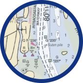
NOAA RNC
Portray water depths, coastlines, dangers, aids to navigation, landmarks, bottom characteristics and other features.
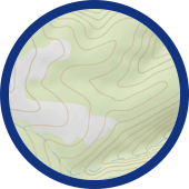
USGS TOPO 24k
Presents elevation (contour lines), hydrography, geographic place names, and a variety of cultural features.
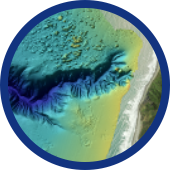
High Resolution Bathymetry
Represents the three-dimensional features that lie underwater. Variations in the sea floor are depicted by color and contour lines. Only available in areas where NOAA has conducted a hydrographic survey.
